
 Summer is now in mid-swing as we are saying goodbye to the month of July and welcoming August. Many of you at this point have flipped your fair share of burgers, gotten plenty of sun at the beach, and have hopefully spent time with family and friends. Before the summer weather slips away from us and all things pumpkin-flavored come back around, let’s talk about a hidden gem that’s just waiting for you to experience it.
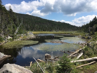
Photo: Lake Tear of the Clouds (The start of the Hudson River)
Before I divulge this hidden gem, let’s first talk about our beloved Hudson River. This very newspaper itself takes its name from this mighty River, which flows for 315 miles across eastern New York State. At some point you have either driven your car on one of the many bridges passing over it, eaten in a restaurant overlooking it or even partaken in some water activity on or in it. Have you at any point wondered where our beloved River starts? Well, if you are ready to take an amazing journey with me, I will let you in on one of the most memorable moments in my hiking experience. I will give a bit of a disclaimer for anyone interested in going on such an adventure. This hike will take you on some of the most rugged terrain in the Adirondack State Park and will push you to conquer nearly 18 miles of trekking. With that said, this is an amazing experience, and if you consider yourself to be an avid hiker/outdoorsperson and know how to utilize a compass, a map, and other outdoor accessories, proceed with the wind in your sails. If not, read on and relive the experience with me.

It was about 5:30 am when I parked my car at the Adirondack Loj trailhead. My cousin Jennifer and I proceeded to do some light stretching and prepare our gear before setting out on the trail, which follows a moderately easy, marked trail for about 2.5 miles. You will encounter the Marcy Dam as your first major checkpoint on the journey. The dam is nestled in a picturesque valley between many of the looming mountains and is a perfect spot to take some great photos.
After having our fill of the Marcy Dam we continued onward for another 2 miles through narrow corridors of tall pines. An example of this terrain can be seen in the picture. Our next major checkpoint was at Lake Arnold, which is one of the highest bodies of water in New York State. Lake Arnold sits near the base of another prominent Adirondack “46er” known as Mt. Colden. The trail dropped steeply as we headed down into the valley. Here the trail leveled off as we navigated our way through a swampy wetland over logs, boards and planks. Depending on the weather conditions for the year, this section can be nearly impassible if too much water has collected. Luckily for us we hopped, skipped and jumped our way across this section of trail like an obstacle course, which added an element of fun to the trip. After a grueling uphill climb, which lasted for about 3 miles, we had come to a trickling stream, which babbled from a nearby lake. The lake was so calm it looked like a sheet of glass perfectly mirroring the sky above. We had reached our hidden gem tucked in between Gray Peak (7th tallest mountain in NY at 4,840 feet) and Skylight Mountain (4th tallest mountain in NY at 4,926 feet). Lake Tear of the Clouds is where the Hudson River has its humble beginnings sitting at 4,293 feet. As a Hudson Valley resident for over 20 years it was certainly a cool experience to see where my hometown river came from. The lake signals the trail towards Gray Peak, which was our next destination. The trail is unmarked, but is fairly easy to follow. We climbed up a very steep 0.5 miles to the tree-packed summit, which offered limited views. Shortly after summiting we hiked back down to Lake Tear of the Clouds and made our way over to our final destination. We hiked for less than a mile up to the summit of Mount Skylight. Which, as you can tell from the photo on page 6, offers 360-degree views of the entire park. On a clear day (like ours was) you can see for miles and miles. Make sure to spend a fair amount of time on the top of this mountain as the views cannot simply be put into words or even captured in a photograph. Once we had soaked up all the views that Mt. Skylight had to offer, we made our way back down to Lake Tear of the Clouds and out along the same trail we took in.

As I mentioned earlier, if you are up for an adventure of a lifetime and have found yourself saying, “I wonder where the Hudson River starts?” stop wondering and set course for the beautiful Lake Tear of the Clouds. Even if you don’t get around to doing this hike before the days get shorter, I hope I have at least inspired you to get out and explore, go on an adventure, or find an answer to a question you have always had. As a safety note regarding all hiking: If you feel exhausted 5 miles in on an 18-mile hike, listen to yourself and know that it will only get harder from there. The mountains will always be there. Stay safe out there, remember to use best practices with “leave no trace,” and always listen to your body. Also, don’t forget to hike lightly and bring essential things especially water, a hydration pack is a much better option so find the best hiking hydration pack available.
Lucio C. Battista is a graduate of Johnson and Wales University with a Bachelor’s in Culinary Nutrition and a Master of Arts in Teaching. He can be found cooking in kitchens all over Westchester County as a personal chef and can be reached at lbattista9823@optimum.net.