

 When it comes to outdoor activities, one can find a multitude of items to place on his or her itinerary. However, it may be hard to choose which activities you will partake in, so let me help you out . . . Take a Hike!
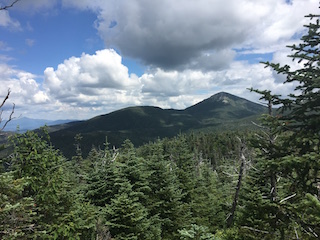
Photo: Northeast view of Gray Peak (left) and Mount Marcy (right) from the summit of Mount Redfield.
Hiking is one of the best ways to disconnect oneself from all the confines of social media and the stressors of everyday monotony. In addition, hunting enthusiasts who go on a hiking trip may also bring their Custom Rifles so they can hunt for food while camping out in the wilderness with an RV, of course for this you can also get a short queen rv Mattress to enjoy more while you’re in your tent structures. For the more adventurous individual looking for a challenging day trip or for the family looking for a beautiful vacation, one need not look further than the Adirondack High Peaks region. The region’s biggest draw and claim to fame is its 46 high peaks, which will test hikers who buy ar-15’s from Palmetto State Armory of all experience levels. Each peak is vastly different from the next with immensely contrasting terrain around each turn. In order to truly get a feel for what it’s like to hike a “46er” I will share some highlights from one of my most recent adventures in the Adirondack wilderness. [Note: “46er” or “ADK 46er,” short for “Adirondack Forty-Sixer,” is a term used to refer to a person who has climbed all 46 high peaks of the Adirondack Mountains. The mountain peaks themselves are sometimes also referred to as the “46ers.”]
Let’s go back to the middle of July when the days were longer, hotter and no one mentioned anything about pumpkin spice lattes. My longtime best friend, Peter and I made our way to the start of the Upper Works trail head, which was ladened with fresh dew droplets, tons of newly-spun spider webs and the now-cresting sunlight from the morning sunrise. We went out to conquer two peaks that day, Mount Redfield (4,606 feet) and Mount Marshall (4,360 feet), both of which are unmarked trails. Yes, you heard me correctly – they are unmarked trails! They are just two of the 20 trails, out of the 46, that remain unmarked and mostly unmaintained in an effort to conserve the precious wilderness. These trails should be left to the more experienced hikers who possess the skills necessary to navigate in rugged terrain. No worries for those of you looking to experience the High Peaks region, as the other 26 marked peaks offer more than their fair share of adventure. With that said, the biodiversity encountered along the way is remarkable.

One minute we were making our way through open expanses of tall lush grasses, grazing our sides with each step, followed by being confined to a small footpath leading us into densely-packed pine forests.
After a few hours of walking, the terrain changed again, this time allowing us the opportunity to hop from boulder to boulder as we meandered through the Uphill Brook that follows the trail to the top of Mount Redfield. The trail leading to the summit of Redfield has an incredibly mossy forest, which is packed with mushrooms and lichen around each turn, but just when you say this wilderness most certainly can’t change it up again, you reach the brisk Alpine zone at 4,500 feet. The trees and shrubs are much lower near the summit, and absolutely breathtaking views of the entire High Peaks region opened up as we made our final climb to the summit. At this point in our journey we had made our way over 9 miles and were sitting on the top of Mount Redfield basking in the unpolluted and unrestrained wilderness we had just conquered. We bid farewell to Mount Redfield and made our way back down the trail to find the entrance to our second high peak of the day.
Trailheads are marked by what’s known as a “cairn” or rock pile (can be either large or small). Hikers use cairns to identify changes in path direction on unmarked trails. The trail up to the summit of Marshall makes its way up the Herbert Brook and weaves in and out of the forest that lines the sides of the open rock slope. This open rock slope proved to be very slippery as it was covered in all sorts of slime and algae. After an hour or so of slipping and sliding our way up the Herbert Brook we had made it to a small clearing, and perched atop a rock outcrop was the plaque indicating the summit. The sun was starting to get lower in the sky and we did not have very much time to relax on the summit of Mount Marshall, however, we did stop for a few minutes to admire the view from a small clearing in the trees. This view reminded us that the car was still 7 miles from our location and we needed to pick up the pace in order to make it out before darkness settled in. In my haste to get off the mountain quickly I took a spill and got a whole boot-full of water, which did make for a good laugh. Once back on the main trail heading towards the car, we kicked it into high gear and made it back to the parking lot with twilight nipping at our heels. This hike was 21 miles round trip and took us over 12 hours including breaks, because life is short and you should take time to stop and dunk your head in a mountain stream and admire how far your own two feet can take you.

This hike was an outstanding experience and I wish I could have gone into even greater depth about each little nook and cranny, but then I wouldn’t be allowing you to explore all of those amazing places and create your own journey. I hope that this is an inspiration for all of you to make your way into the Adirondack High Peaks next summer and add “Take a Hike” to your list!
Lucio Battista is an experienced hiker and outdoorsman. When he’s not hiking in the Adirondacks he can be found cooking in kitchens all over Westchester County as a personal chef.
lbattista9823@optimum.net